Unit 12 - Script User Interface
Standard input
In the script prepared in Unit 11 - PyGRASS scripting some tools (r.recode,
r.colors) use hardcoded paths to the input files. See code
below (rules option):
    Module("r.recode",
           overwrite=True,
           input="ndvi",
           output="ndvi_class",
           rules="/home/martin/git/gismentors/grass-gis-workshop-jena/_static/models/reclass.txt")

    Module("r.colors",
           map="ndvi_class_filled",
           rules="/home/martin/git/gismentors/grass-gis-workshop-jena/_static/models/colors.txt",
           offset=0,
           scale=1)
Content of input files can be defined as a string object and transfered
to the command via standard input (stdin_). See a sample code
below:
    Module("r.recode",
           overwrite=True,
           input="ndvi",
           output="ndvi_class",
           rules="-",
           stdin_="-1:0.1:1\n0.1:0.5:2\n0.5:1:3")

    Module("r.colors",
           map=options["output"],
           rules="-",
           stdin_="1 grey\n2 255 255 0\n3 green",
           offset=0,
           scale=1)
Note that many of GRASS tools allows sending data via standard input
by option value - (dash). In our case the both commands will be
changed to use rules="-" syntax.
Task
Define a cleanup routine to remove intermediate data by g.remove tool.
def cleanup():
    Module('g.remove', flags='f', name='region_mask', type='vector')
    Module('g.remove', flags='f', name='ndvi', type='raster')
    Module('g.remove', flags='f', name='ndvi_class', type='raster')
    Module('g.remove', flags='f', name='ndvi_class_area', type='raster')
    Module('g.remove', flags='f', name='ndvi_class_filled_i', type='raster')
User interface (UI)
Let’s improve UI generated by Graphical Modeler in Unit 10 - Python intro.
# %module
# % description: NDVI computation version 3.
# %end
# %option
# % key: voverlay1_ainput
# % description: Name of input vector map (A)
# % required: yes
# % type: string
# % key_desc: name
# % answer: jena_boundary
# %end
# %option
# % key: rreclassarea6_value
# % description: Value option that sets the area size limit (in hectares)
# % required: yes
# % type: double
# % answer: 0.16
# %end
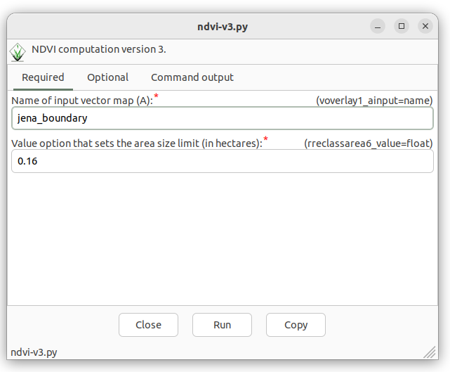
Fig. 74 Generated GUI dialog with voverlay1_ainput option.
Let’s change UI by defining parameters below:
region: vector map defining a computation region (required)clouds: vector map with cloud mask features (required)red: input red channel (required)nir: input nir channel (required)min_area: threshold for removing small areas (optional)output: output vector map (required)
UI definition below.
# %module
# % description: NDVI computation version 4.
# %end
# %option G_OPT_V_INPUT
# % key: region
# % description: Name of input vector region map
# %end
# %option G_OPT_V_INPUT
# % key: clouds
# % description: Name of input vector clouds map
# %end
# %option G_OPT_R_INPUT
# % key: red
# % description: Name of input red channel
# %end
# %option G_OPT_R_INPUT
# % key: nir
# % description: Name of input NIR channel
# %end
# %option
# % key: min_area
# % description: Threshold for removing small areas in m2
# %type: integer
# % answer: 1600
# %end
# %option G_OPT_V_OUTPUT
# %end
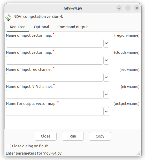
Fig. 75 GUI dialog with input options.
In the script input parameters are still hardcoded, eg.
    Module("v.overlay",
           overwrite=True,
           ainput=options["voverlay1_ainput"],
           alayer="1",
           atype="auto",
           binput="MaskFeature",
           blayer="1",
           btype="area",
           operator="not",
           output="region_mask",
           olayer=['1', '0', '0'],
           snap=1e-8)
Input parameters are accesible by options and flags
objects which are generated by parse() function.
options, flags = parser()
Options and flags objects are Python dictionaries, where parameters are accessible by keys. See list of changes below:
    Module("v.overlay",
           overwrite=True,
           ainput=options["region"],
           alayer="1",
           atype="auto",
           binput=options["clouds"],
           blayer="1",
           btype="area",
           operator="not",
           output="region_mask",
           olayer=['1', '0', '0'],
           snap=1e-8)

    Module("g.region",
           overwrite=True,
           vector="region_mask",
           align=options["red"])
    Module("i.vi",
           overwrite=True,
           output="ndvi",
           viname="ndvi",
           red=options["red"],
           nir=options["nir"],
           storage_bit=8)
    Module("r.reclass.area",
           overwrite=True,
           input="ndvi_class",
           output="ndvi_class_area",
           value=int(options["min_area"]) / 1e4,
           mode="greater",
           method="reclass")

    Module("r.grow.distance",
           overwrite=True,
           input="ndvi_class_area",
           value=options["output"],
           metric="euclidean")

    Module("r.colors",
           map=options["output"],
           rules="-",
           stdin_="1 grey\n2 255 255 0\n3 green",
           offset=0,
           scale=1)
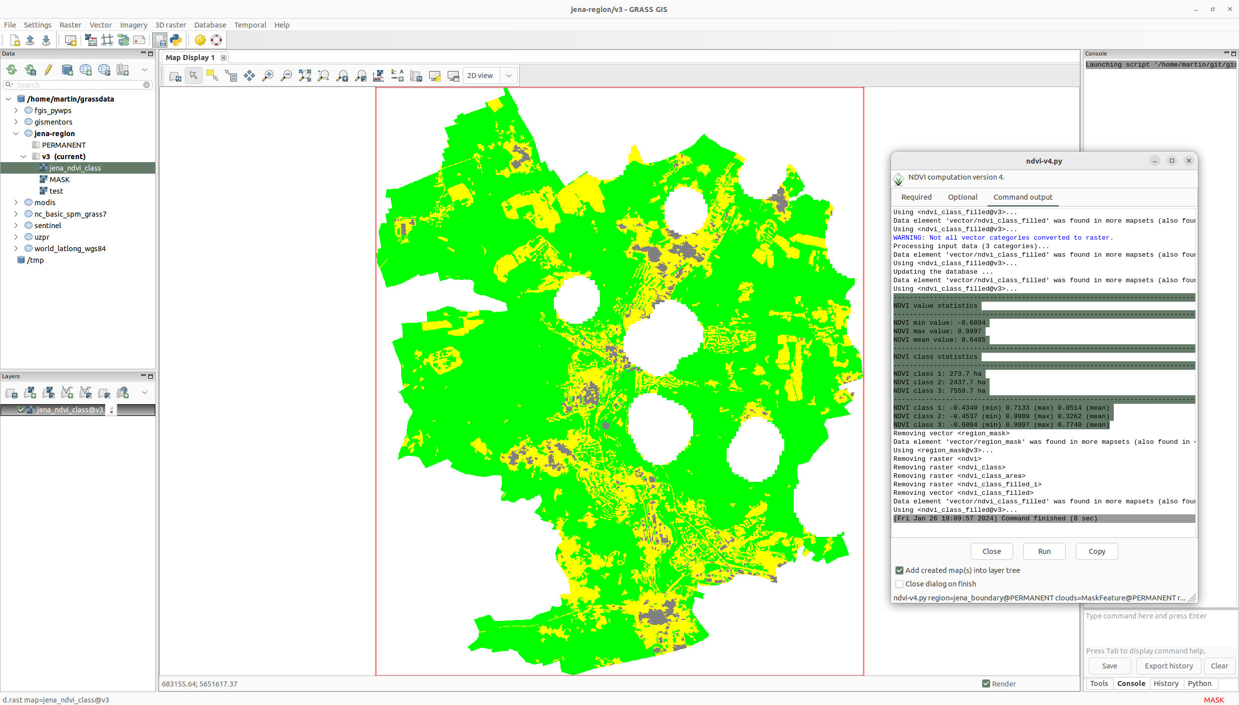
Fig. 76 Improved NDVI script in action.
Sample script to download: ndvi-v4.py