Unit 17 - DTM script parallelization
This unit is focused on computing parallelization. Sample script below produces seamless DTM (Digital Terrain Model, see Unit 16 - Lidar, DTM interpolation) from bunch of LAS/LAZ files. Computation will be split into tiles and performed in parallel.
DTM interpolation in parallel
User interface contains two major parameters, directory (line 6) for input directory with input LAS/LAZ files, and elevation (line 9) name for output elevation raster map mosaics. The resolution of output DTM is defined by resolution parameter (line 13). And finally number of processes running in parallel will be controlled by nproc (line 18) parameter.
A script consists of three main functions:
1. import_files() to import input LAS/LAZ files (line
33). Import process can be done in parallel by
ParallelModuleQueue from PyGRASS library (see
Unit 11 - PyGRASS scripting for PyGRASS intoruction), lines 37, 42, 57-58, 60.
2. create_dtm_tiles() to compute DTM per tile (line 67)
using v.surf.rst. DTM tiles need to be computed with a
reasonable overlap in order to create seamless mosaics, see
73-76. Tiles can be processed in parallel too, see
nproc option on line 82.
3. patch_tiles() to patch DTM tiles together by
r.series, see 86. From overlapping cell values is
computed an average value. This is main reason why r.patch
is not used here.
  1#!/usr/bin/env python
  2
  3#%module
  4#% description: Creates DTM from input LAS tiles.
  5#%end
  6#%option G_OPT_M_DIR
  7#% required: yes
  8#%end
  9#%option G_OPT_R_ELEV
 10#% description: Name for output elevation raster map mosaics
 11#%end
 12#%option
 13#% key: resolution
 14#% description: Output resolution
 15#% type: double
 16#%end
 17#%option
 18#% key: nprocs
 19#% description: Number of processes per tile
 20#% answer: 1
 21#% type: integer
 22#%end
 23
 24import os
 25import sys
 26import time
 27from copy import deepcopy
 28
 29import grass.script as gs
 30
 31from grass.pygrass.modules import Module, ParallelModuleQueue
 32
 33def import_files(directory):
 34    start = time.time()
 35
 36    # queue for parallel jobs
 37    queue = ParallelModuleQueue(int(options['nprocs']))
 38
 39    import_module = Module('v.in.lidar',
 40                           flags='otb',
 41                           overwrite=True,
 42                           run_=False
 43    )
 44
 45    maps = []
 46    for f in os.listdir(directory):
 47        if os.path.splitext(f)[1] != '.laz':
 48            continue
 49        fullname = os.path.join(directory, f)
 50        basename = os.path.basename(f)
 51        # '-' is not valid for vector map names
 52        # vector map names cannot start with number
 53        mapname = "las_{}".format(os.path.splitext(basename)[0].replace('-', '_'))
 54
 55        maps.append(mapname)
 56        gs.message("Importing <{}>...".format(fullname))
 57        import_task = deepcopy(import_module)
 58        queue.put(import_task(input=fullname, output=mapname))
 59
 60    queue.wait()
 61
 62    if not maps:
 63        gs.fatal("No input files found")
 64
 65    return maps
 66
 67def create_dtm_tiles(maps, res, nprocs, offset_multiplier=10):
 68    offset=res * offset_multiplier
 69
 70    for mapname in maps:
 71        Module('g.region',
 72               vector=mapname,
 73               n='n+{}'.format(offset),
 74               s='s-{}'.format(offset),
 75               e='e+{}'.format(offset),
 76               w='w-{}'.format(offset)
 77        )
 78
 79        Module('v.surf.rst',
 80               input=mapname,
 81               elevation=mapname,
 82               nprocs=nprocs,
 83               overwrite=True
 84        )
 85
 86def patch_tiles(maps, output, resolution):
 87    gs.message("Patching tiles <{}>...".format(','.join(maps)))
 88    Module('g.region', raster=maps, res=resolution)
 89    Module('r.series', input=maps, output=output, method='average', overwrite=True)
 90    Module('r.colors', map=output, color='elevation')
 91
 92def main():
 93    start = time.time()
 94
 95    maps = import_files(options['input'])
 96    create_dtm_tiles(maps,
 97                     float(options['resolution']),
 98                     int(options['nprocs'])
 99    )
100    patch_tiles(maps,
101                options['elevation'],
102                options['resolution']
103    )
104
105    gs.message("Done in {:.0f} min".format((time.time() - start) / 60.))
106
107    return 0
108
109if __name__ == "__main__":
110    options, flags = gs.parser()
111
112    sys.exit(main())
Sample script to download: create-dtm.py
Note
The script is taking a long time with all the tiles from
/home/geodata/lidar/laz directory. Choose few tiles
for testing.
Create a new directory eg. /tmp/lidar and link some (2
or 3) of the LAZ files with
ln -s /home/geodata/lidar/laz/32-1-514-136-15.laz /tmp/lidar/
Use /tmp/lidar as input in the create-dtm.py script
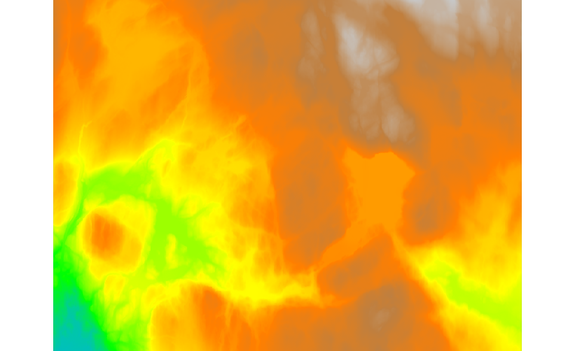
Fig. 100 DTM created from all available tiles.
DTM comparision
In this session we are going to calculate the Canopy Height Model (CHM), it is the difference between interpolated DSM and imported EUDEM DTM
The CHM is computed using r.mapcalc, executing the difference between DSM and DTM
r.mapcalc expression="chm = DTM_laz - dem"
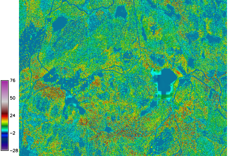
Fig. 101 The CHM map.
Tip
To have better CHM it is possible to download DTM files from hoydedata.no. You can import all TIF files using checking Directory as Source type and selecting the directory where the TIF files are.
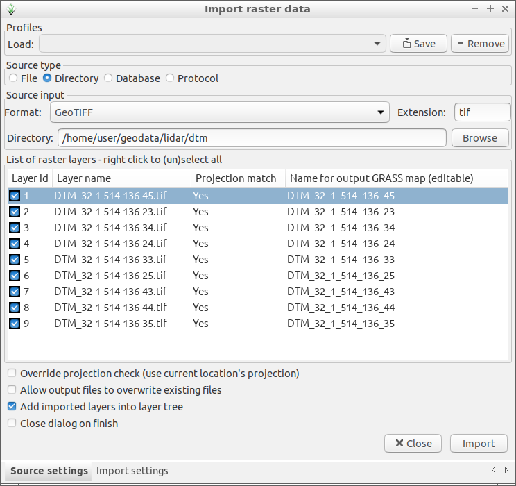
Fig. 102 Import all DTM TIF files from for exampe geodata/lidar/dtm/
directory.
Once DTM tiles are imported you can patch them using r.series and set the color to elevation by r.colors.
r.series input=`g.list type=raster pattern=DTM_* sep=','` output=DTM_patch
r.colors map=DTM_patch color=elevation
Fig. 103 Patched DTM.
Now it is possible to run the previous r.mapcalc command changing dem with DTM_patch